
Nevada-Arizona State Line Location
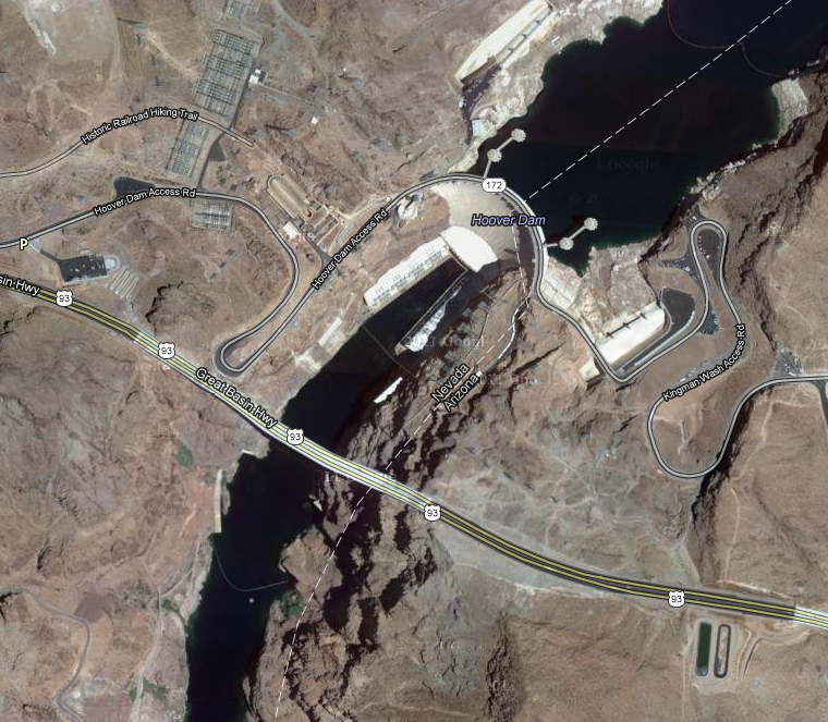
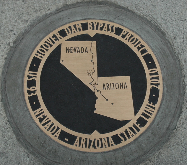
When I walked across the bridge in December 2010, I saw and photographed the marker for the Nevada-Arizona state line. That was just east of the spot where I took the photo that I posted showing the dam. I also took a photo of the dam from right at the marker, and it differs only trivially from the image that I posted. I have assumed that the state line in that immediate vicinity goes down the center of the channel of the river.
Today I was browsing Google Maps and noticed that Google shows the state line significantly offset to the east. According to that map (image below), the entire waterway and both banks from the dam down past the bridge are completely in Nevada. The bridge arch support base on the east side is located essentially where Google Maps shows the state line. That reported position for the state line has to be 100 yds. or more away from where I saw the marker on the bridge.
Is that correct? Is the entire power plant plus all of that portion of the river in Nevada? Alternatively, can Google Maps be that far off? It doesn't appear to be just an error in registration of the map coordinates -- according to the image, the state line has an abrupt direction change/offset right at the dam.
Does anyone have good information on this topic?
BTW, I recall hearing some report of a brief international conflict in Central America due to a Google Maps error. I don't think my question warrants the governors calling out the troops, but I would like to know what the correct info is.
Thanks for any help you may have.
My knee-jerk reaction is to assume that it's some sort of administrative thing, and it's easier if the business side of things is all in one state, but allow the tourist things to have a more natural dividing line.
Except that it continues to extend into AZ far longer than necessary.
And a couple miles south, it dips into AZ again:
Admin note: removed image www.djteddybear.com/images/google_nv_az.JPG
On the other hand, MapQuest also shows a bent border, except it bends the other way, and remains entirely in the river:
Admin note: removed image www.djteddybear.com/images/mapquest_nv_az.JPG
Very strange....
That takes the number of US states I've set foot on to, let's see, CA, FL, TX, GA, NY, AZ, NV (Ontario isn't a state, is it? <w>): Seven. Of course, all I did in Arizona was step on it. Georgia at least involved a 3-hour layover in Atlanta and a connecting flight to Orlando.
Quote: NareedI took the time to walk on the highway on top just to be able to say I've set foot in Arizona. As I recall, the marker was about where the map in the OP says the line is.
I agree that the marker on the dam is pretty much in the middle and matches what the Google Maps image shows. The discrepancy is downstream and at the bridge, where the indicated state line is nowhere near the marker is, out in the middle of the bridge.
I might have misunderstood you, Nareed; you were talking about "highway on top" of the dam, weren't you? I don't think anyone but construction workers were on the bridge in 2008.
I guess I don't understand what an organization membership would have to do with the location of the state line.Quote: rdw4potusNevada is in the West Connect Regional Transmission Organization for electricity, but Northwestern AZ is not.
Quote: DocI might have misunderstood you, Nareed; you were talking about "highway on top" of the dam, weren't you?
Of course. If I meant the bridge, I'd have said "the roadway" :P
Seriously, the bridge was under construction back in '08. It would have been too much trouble to get on it then.
Quote: DJTeddyBearThat is odd.
My knee-jerk reaction is to assume that it's some sort of administrative thing, and it's easier if the business side of things is all in one state, but allow the tourist things to have a more natural dividing line.
Except that it continues to extend into AZ far longer than necessary.
And a couple miles south, it dips into AZ again:
It seems that Nevada is only one of two states to significantly expand its borders after becoming a state. During the civil war when Nevada was accepted as a state, the southern boundary was the same as the northern boundary of present day Arizona. It would actually be north of Clark County.
Arizona had pro-confederate leanings when she was a territory during the civil war. As a result, the Union gave Nevada the entire Colorado river, instead of drawing the border down the middle of the river as was customary with navigable rivers.
At the time, the river was not very accessible

Quote: Doc
I guess I don't understand what an organization membership would have to do with the location of the state line.
Maybe nothing, and probably the membership was established after the line was drawn. But it makes sense for one state and one (and only one) Regional Transmission Organization - in this case, West Connect - to be responsible for oversight of the power off-takes from the dam.
I would rather see the plant/dam be regulated by FERC, West Connect, and Nevada than be regulated by FERC, West Connect, NV, AZ, and whatever RTO AZ is in.
That kinda makes sense.Quote: pacomartinArizona had pro-confederate leanings when she was a territory during the civil war. As a result, the Union gave Nevada the entire Colorado river, instead of drawing the border down the middle of the river as was customary with navigable rivers.
I then assume that the dam lowered the water level of the river downstream, which may explain why the state line stays in AZ more than seems necessary, as well as why it dips into AZ a mile or so south.
However, it certainly does not explain the weird zig-zag at the point of the dam.
Quote: DJTeddyBearHowever, it certainly does not explain the weird zig-zag at the point of the dam.
And it doesn't explain why the state line marker on the bridge is not even close to the state line, if that line is really east of the river.
Here is a link to a short article describing the history of Arizona's borders: Arizona Border Article.
Too add to the argument that online maps tend to have bad borders, check out this look at Puerto Iguazu, Argentina. The confluence of the three rivers form the borders between Argentina, Brazil, and Paraguay. However, on GoogleMaps, it is about a mile north of where it should be.
Quote: WizardI agree with Aye above, that the problem is with the map. I've always been told that the state line is half way between both shores.
Google maps differs from several of these corners.
Official borders of Arizona
(1) Beginning at a point on the Colorado River twenty English miles below the junction of the Gila and Colorado Rivers, as fixed by the Gadsden Treaty between the United States and Mexico, being in
latitude thirty-two degrees, twenty-nine minutes, forty-four and forty-five one- hundredths seconds north and
longitude one hundred fourteen degrees, forty-eight minutes, forty-four and fifty-three one -hundredths seconds west of Greenwich;
(32º 29' 44.45" -114º 48' 44.53") southwest corner of Arizona
(2) thence along and with the international boundary line between the United States and Mexico in a southeastern direction to Monument Number 127 on said boundary line in latitude thirty-one degrees, twenty minutes north;
thence east along and with said parallel of latitude, continuing on said boundary line to an intersection with the meridian of longitude one hundred nine degrees, two minutes, fifty-nine and twenty-five one-hundredths seconds west, being identical with the southwestern corner of New Mexico;
(31º 20' 0.00" -109º 02' 59.25") southeast corner of Arizona
(3) thence north along and with said meridian of longitude and the west boundary of New Mexico to an intersection with the parallel of latitude thirty-seven degrees north, being the common corner of Colorado, Utah, Arizona, and New Mexico;
(36°59' 56.31532" -109°02'42.62019) Four Corners: precise
(4) thence west along and with said parallel of latitude and the south boundary of Utah to an intersection with the meridian of longitude one hundred fourteen degrees, two minutes, fifty-nine and twenty-five one-hundredths seconds west, being on the east boundary line of the State of Nevada;
(37º -114º 02' 59.25") northwest corner
(37° 0'1.43" -114° 3' 2.14") Google Earth
(5) thence south along and with said meridian of longitude and the east boundary of said State of Nevada, to the center of the Colorado River;
Mesquite
(6) thence down the mid-channel of said Colorado River in a southern direction along and with the east boundaries of Nevada, California, and the Mexican Territory of Lower California, successively, to the place of beginning.
Quote: WizardI agree with Aye above, that the problem is with the map. I've always been told that the state line is half way between both shores. ... The confluence of the three rivers form the borders between Argentina, Brazil, and Paraguay. However, on GoogleMaps, it is about a mile north of where it should be.
Having the state line in the river is what I expected (and think I said in the OP.) Pacomartin's description confirms this, and I assume that he obtained it from an official source. I just wonder how/where Google Maps comes up with their map of the border, with turns that obviously don't follow the river. Same puzzlement for the South American borders you mention.
Is Google Maps just screwing things up or do they have some source that should be reliable but is in error?
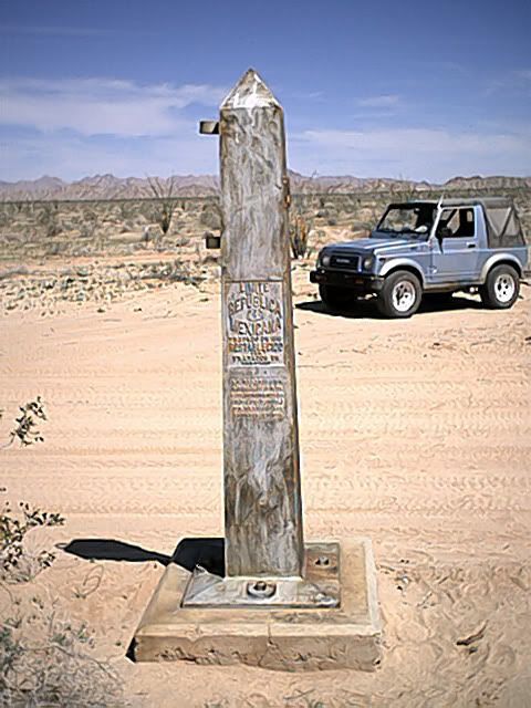
The obelisks were constructed after the war in the 1850's to mark the border.
Monument #127 is right at the corner in the middle of Arizona (near Nogales border crossing). If you look at it in Google Earth they have something marked monument tank which looks like a parking lot in the middle of nowhere. It's about 1/3 of a mile from where Google shows the corner in the Arizona border.
Monument #127 is bigger than most of them

Well, if you look at the satellite version of the map that you linked, you can see that they still show the intersection of the borders slightly away from where the monument is located in the satellite image, so I don't think that monument-positioning error explains the diagonal section of the border.Quote: Wizard... Was this a recent thing to put the memorial at the actual point where the four states touch. You may recall they figured out recently the memorial was off by about 20 feet several years ago.
If the Google Maps version of the Utah-Colorado border half a mile farther north is correct (and I have no idea one way or another), then the diagonal adjustment would be necessary in order for there to be a four corners at all. Otherwise, Utah would not reach far enough east to touch New Mexico even at a point.
There was a thread here some time back that discussed a book, I think, that went into detail about the shape of all the states and how they got that way. I never followed up on that book, but I do know that several state borders that appear as straight lines with a casual glance really have some offsets. It is plausible to me that the UT-CO border and the AZ-NM border are at different longitudes for the most part, with a slight adjustment near four corners so that there is a single point of common contact. It is also plausible to me that Google Maps is not so accurate in the details as some of us nerdy, obsessive-compulsive sorts might have hoped. Is there a better, available-for-free, on-line map resource? (Yes, I want everything, and I don't want to pay for it.)
Quote: hook3670... there was a real live fued back in the day between two families on either side of the border and it was the original Hatfields and McCoys.
That was a genuine feud, mostly in WVa, I think. Eventually the McCoys retreated across a range or two of mountains to the vicinity of Blacksburg, VA, where I grew up. There is a small community/town of McCoy, VA near Blacksburg and on the banks of the New River. Lots of folks named McCoy in that area.
Quote: hook3670I think the History channel has a series of shows called "How States Got Their Shape". They tackle three or four states per episode. I have only watched one and it was quite fascinating. it was on Virginia, West Virginia and Kentucky. believe it or not from what I remeber(its been a while since I watched the show) there was a real live fued back in the day between two families on either side of the border and it was the original Hatfields and McCoys.
Quote: A River Runs Through ItPremiere Date: 05/03/2011
How has water has literally shaped the States? There's surprising history hidden in the blue, squiggly lines on the map. Did the founding fathers make a mistake along the Georgia Tennessee border? Can that boundary actually change because of water? Why does Maine have so much water? Why was Nevada was left high and dry? -- All these answers can be found in the unique shapes of these states.
TVPG
