
Earthquake
More news as it develops.
* 35 km (22 miles) S (171°) from Teloloapan, Guerrero, Mexico
* 43 km (27 miles) NNW (339°) from Chichihualco, Guerrero, Mexico
* 45 km (28 miles) SW (219°) from Iguala, Guerrero, Mexico
* 133 km (82 miles) N (6°) from Acapulco, Guerrero, Mexico
at 7.47pm central time.
Stay safe.
Quote: boymimboUSGS records it as a 6.7.
Thanks.
6.7 is bad, but not too bad. The good news is that networks didn't interrupt programming to report it. It took me a few minutes to even find news. So far I haven't heard of any significant damage. Reports from Acapulco don't indicate anything other than jammed cel networks.
Quote:Stay safe.
Thanks. It helps living in a stable area. Of course, this morning I spent nearly 4 hours at one of the worst quake areas in the city.
Quote: NareedThanks. It helps living in a stable area. Of course, this morning I spent nearly 4 hours at one of the worst quake areas in the city.
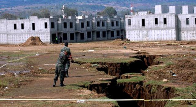
We get stories about cracks developing from the water extraction. While not an earthquake, they do look scary
From what you are saying, it sounds like you live in an area referred to as piedmont or an area of land formed or lying at the foot of a mountain or mountain range.
Until now I didn't realize that the epicenter of the 1985 quake was in the ocean, and was not anywhere near Mexico City.
Quote: Mexico city vulnerability
While not on or near any fault line like San Francisco or Los Angeles, Mexico City is vulnerable to earthquakes. The main reason for this is the surface geology of the area, especially the downtown area. The city grew from an island in the middle of Lake Texcoco outward, as this lake was eventually drained. The near surface geology of this area is classified into three sections:
(1) the old lake bed which is soft clay from volcanic ash with a high water content,
(2) a piedmont area, much of which is capped by 5 to 30 meters of lava less than 2,500 years old, and
(3) an old river delta area.
On the bed of the historic lake, the prevailing silt and volcanic clay sediments amplify seismic shaking. Damage to structures is worsened by soil liquefaction which causes the loss of foundation support and contributes to dramatic settlement of large buildings.
Another factor is that the old lakebed resonates with certain seismic waves and low frequency signals. This lakebed has a natural "pitch" of one cycle every 2.5 seconds making everything built on the bed vibrate at the same frequency. Unfortunately, this is the same �pitch� as a number of shallow earthquake waves. This resonance amplifies the effects of the shock waves coming from an earthquake far away.
However, only certain types of structures are vulnerable to this resonance effect. Taller buildings have their own frequencies of vibration. Those that are six to fifteen stories tall also vibrate at the 2.5-second cycle, making them act like tuning forks in the event of an earthquake. The low-frequency waves of an earthquake are amplified by the mud of the lakebed, which in turn, is amplified by the building itself. This causes these buildings to shake more violently than the earthquake proper as the earthquake progresses. Many of the older colonial buildings have survived hundreds of years on the lakebed simply because they are not tall enough to be affected by the resonance effect.
Magnitude 6.5
Date-Time
Sunday, December 11, 2011 at 01:47:26 UTC
Saturday, December 10, 2011 at 07:47:26 PM at epicenter
Time of Earthquake in other Time Zones
Location 18.038°N, 99.796°W
Depth 64.9 km (40.3 miles)
Region GUERRERO, MEXICO
Distances 42 km (26 miles) SW of Iguala, Guerrero, Mexico
56 km (34 miles) ESE of Arcelia, Guerrero, Mexico
62 km (38 miles) NNW of Chilpancingo, Guerrero, Mexico--neic
166 km (103 miles) SSW of MEXICO CITY, D.F., Mexico
Location Uncertainty horizontal +/- 14.5 km (9.0 miles); depth +/- 9.8 km (6.1 miles)
Quote: pacomartinWe get stories about cracks developing from the water extraction. While not an earthquake, they do look scary
I read of them in the paper, same as you. I've yet to see one up close. I think they concentrate mostly in the southwest part of the city.
Quote:From what you are saying, it sounds like you live in an area referred to as piedmont or an area of land formed or lying at the foot of a mountain or mountain range.
<shrug> I don't know if where I live qualifies as the foot of a mountain, but there are mountains pretty close by.
anyway, the press reports state the quake lasted about 45seconds, which is a very long time as quakes go. Damage and casualties were reported to be light.
So far there seems to be little damage.
Quote: NareedThere was another quake today,a round noon local time. Reports keep increasing its magnitude, but the average is about 7.8 Richter. That's pretty strong. No word about duration as yet, but there's been an aftershock already. So far there seems to be little damage.
That is fairly close to where the president's 13-year-old daughter is on spring break. Considering the U.S. effort to clamp down on covering that, we will probably be treated to not much more than very low-level murmuring on the subject.
Quote: SanchoPanzaThat is fairly close to where the president's 13-year-old daughter is on spring break.
The epicenter was about 125 miles away from Malia Obama. The 1931 earthquake was 75 miles from the city, but it destroyed 70% of the city. It's a pretty active area. When I was there the ground shook frequently.
The 1931 earthquake was one of the first major disaster to be captured on film by the famed director Sergei Eisenstein.
Quote: s2dbakerIt was a deep one too. 5.5 richter and 77km deep @ Huetamo de Nunez
Deep is good.
I'm kind of used to them, too. What's hard to take is the hysteria they unleash, even with minor tremors. If I'm in a stable area, which I am most of the time, well, they can be a little frightening, but I try to keep calm. I wish other people did the same.
Quote: NareedANother one, just a few minutes ago. Call it 11:40 am local (cetnral daylight savings time right now). It felt milder than previous ones. They're getting rather tiresome. There were some in April, too.
The U.S. Geological Survey says the 5.7 quake was centered 85 miles from Michoacan's capital, Morelia. An earlier 5.0 quake struck 114 miles off the coast of Cabo San Lucas in the state of Baja California Sur. Neither state reported serious damage or injuries.
I didn't like Morelia very much. I loved Patzcuaro.
Quote: pacomartinI didn't like Morelia very much.
Too lively at night?
Quote: SanchoPanzaToo lively at night?

I think I have seen most of the colonial cities of Mexico now (Cuernavaca is the biggest exception), and I thought Morelia was a bit staid. The architecture is more like Washington DC. It's a little too classical. I much preferred Puebla, Acapulco, Zacatecas, Oaxaca City, or Merida.
My hotel was very uncomfortable. That may have colored my judgement.
