
Book recommendation for geography nerds
No need to buy the book, just visit your local library.
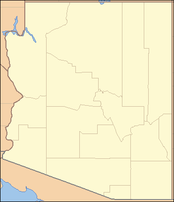
I'm confused.Quote: teddysOr why the southern border of Arizona does not extend all the way to California, but stops short near Yuma?
Doesn't Arizona border California?
Quote: cclub79I noticed it was airing on the History Channel last night and watched a bit. Something I think is most misunderstood (that I knew as a former resident of both Maryland and Pennsylvania) is the fact that the Mason Dixon Line had nothing to do with Slavery or the Civil War, other than the Confeds High Water Mark in the North was just north of it in Gettysburg, exactly 147 years ago today. Maryland was a free state, hence the state nickname. It was a PA/MD/DE border dispute 100 years before the Civil War that created the line.
Maryland was slave state. Slavery was abolished in 1864. Maryland's slaves were not freed by the Emancipation Proclamation because Maryland had not seceded. They adopted a new Constitution that had an article barring slavery.
Here is the info I found on the "Free State" nickname:
"The nickname "Free State" was created by Hamilton Owens, editor of the Baltimore Sun. In 1923, Georgia Congressman William D. Upshaw, a firm supporter of Prohibition, denounced Maryland as a traitor to the Union for refusing to pass a State enforcement act. Mr. Owens thereupon wrote a mock-serious editorial entitled "The Maryland Free State," arguing that Maryland should secede from the Union rather than prohibit the sale of liquor. The irony in the editorial was subtle, and Mr. Owens decided not to print it. He popularized the nickname, however, in later editorials."
From: http://www.msa.md.gov/msa/mdmanual/01glance/html/nickname.html
Having living in Maryland through the 90's, I was told that whoever drew the Mason Dixon line was partial to Pennsylvania, so drew it as far south as reasonably possible, yet still keep Maryland in one piece.
One geographic oddity I've always wondered about is the diagonal border between CA and NV, from Lake Tahoe to southern tip of NV. It looks like a straight line, but it makes a very slight angle near Oasis Ranch, CA. Somebody told me it was the result of a surveying error, but I'd prefer to get a better explanation than that.
CA-NV border
Another straight border, that isn't, is the one between Utah and Colorado. Notice how it cuts into CO near the four-corner monument, perhaps to correct for the incorrect placement of the monument.
UT-CO border
Quote: DJTeddyBearI'm confused.
Doesn't Arizona border California?
Observe how the southern border line stops short of California and leaves that little stretch of border with Baja California N.
Okay, now that I think about it this wasn't one of the more interesting ones ... (Yes, it has to do with the Gadsden Purchase and not leaving Yuma isolated next to Mexico ... or something like that.)
Quote: WizardI thought Arizona and New Mexico got extra land from Mexico via the Gasden purchase.
AZ did for sure. When I lived in Phoenix they said it was part of the purchase. What I wonder about the Gadsden Purchase is what happened to the several ten thousand acres that was cut out of it? Anti-Slavery and Anti-Expansion forces in Congress didn't want the purchase at all but were pragmaic enough to know that it was needed for the RR. As a compromise something like 50,000 acres was cut off of the purchase. But they rarely say what it would have looked like otherwise.
Word was Mexico was willing to sell off lots more of their country at the time. I have heard we could have bought all of Baja California and who knows what else. If it hadn't been for slavery I bet we might have bought all of it, and the resulting, smaller Mexico would have not bee viable and all become part of the USA by 1900. Or else just a smaller nation like Hondauras, Nicaragua, etc. Imagine.
I think that might be my next book purchase.
Quote: RonCMaryland was slave state. Slavery was abolished in 1864. Maryland's slaves were not freed by the Emancipation Proclamation because Maryland had not seceded. They adopted a new Constitution that had an article barring slavery.
Here is the info I found on the "Free State" nickname:
"The nickname "Free State" was created by Hamilton Owens, editor of the Baltimore Sun. In 1923, Georgia Congressman William D. Upshaw, a firm supporter of Prohibition, denounced Maryland as a traitor to the Union for refusing to pass a State enforcement act. Mr. Owens thereupon wrote a mock-serious editorial entitled "The Maryland Free State," arguing that Maryland should secede from the Union rather than prohibit the sale of liquor. The irony in the editorial was subtle, and Mr. Owens decided not to print it. He popularized the nickname, however, in later editorials."
From: http://www.msa.md.gov/msa/mdmanual/01glance/html/nickname.html
Thanks for the correction. I guess I didn't live there long enough! While the name "Free State" came later, Maryland was not part of the Confederacy and thus Union-loyal, making the Mason-Dixon line not the "border" between the North and South. When the Confederate army was marching North, legend has it that they were prepared to burn the city of Frederick, but an old woman stood on her front steps waving the American Flag and Stonewall Jackson was impressed with her bravery and spared the city. There are many points of interest in Frederick named after the woman, Barbara Fritchie, but the story's truth is questioned today.
I have the book the post is referencing. It's very informative, but it's organized alphabetically by state, whereas I think a chronological setup would have made much more sense. You find yourself unable to simply read it, because you are bouncing around to follow references to other states' borders. It's like reading history of the United States alphabetically by Presidents' last names.
Quote: teddysI thought Maryland's nickname was "The Old-Line State?"
I guess there's no rule to the max number of nicknames...Connecticut is Nutmeg and Constitution.
The untrusted legislature was forced out of Annapolis by Butler early in the war and into what has been described as an armed camp in Frederic.
I like learning about areas like the Northwest Angle, or the Kentucky Bend exclave, which is part of Kentucky, but physically touches Tennessee, and is also closer to Missouri than the rest of Kentucky.
Quote: AZDuffmanWord was Mexico was willing to sell off lots more of their country at the time. I have heard we could have bought all of Baja California and who knows what else. If it hadn't been for slavery I bet we might have bought all of it, and the resulting, smaller Mexico would have not bee viable and all become part of the USA by 1900. Or else just a smaller nation like Hondauras, Nicaragua, etc. Imagine.
Baja would have been the most obvious purchase since it was nearly uninhabited at the time.
Still, the Mexican states that border the USA even today only contain about 25% of the countries population. I doubt that we would have bought enough to make Mexico unviable today. Even without Baja (North and South), Coahuilla, Chihuahua, Nuevo Leon, Sonora and Tamaulipus. Mexico would still be the largest Spanish speaking countryin the world today.
Quote: pacomartinBaja would have been the most obvious purchase since it was nearly uninhabited at the time.
Still, the Mexican states that border the USA even today only contain about 25% of the countries population. I doubt that we would have bought enough to make Mexico unviable today. Even without Baja (North and South, Chihuahua, Nuevo Leon,Sonora and Tamaulipus ) Mexico would still be the largest Spanish speaking countryin the world today.
I'm not at all an expert, but my understanding is the northern states you mention are similar in topography to the USA Southwest. Then near the center of Mexico you have some very rugged mountains, unfit for agriculture. If Mexico lost this it would be like the USA losing the Great Plains States, the breadbasket. Take away Baja and the USA could have shut Mexico's western ports off at will. Combined this would have left Mexico in bad shape, indeed.
Now, I may be wrong, I admit to not knowing much about Mexico's internal structure. Just going by what I have seen at Stratfor and some other places.
Quote: AZDuffmanTake away Baja and the USA could have shut Mexico's western ports off at will. Combined this would have left Mexico in bad shape, indeed.
When USA occupied Mexico City in September 1847 it would probably have not been that difficult to keep control of the whole country. Population of all of Mexico was less than 8 million at the time. However, there was very little support in northern United States for permanently occupying Mexico and fighting a long term war of attrition. USA just wanted the northern half of the country (the future New Mexico, Arizona, California Nevada and parts of Utah and Colorado). Texas has previously secured independence, but was now joining with the USA as a state.
US CENSUS
17.1 million - 1840
23.2 million - 1850
Abraham Lincoln was a US representative for the single term from (March 4, 1847 to March 3, 1849). He was a very vocal anti-war advocate. The fact is even more remarkable considering he was opposing a war that the USA was actively fighting, and not a just a war that was being considered.
During his term as president he remained faithful to Mexican independence, and smuggled guns to Benito Juarez for his fight against the European powers (even as the American Civil War raged). Today he remains the most honored US president in Mexico. There is a big statue of him in Tijuana. Benito Juarez is respected in America (by the relatively small percentage of Americans who know who he was).
In the latter half of the 19th century American interests controlled a large part of the economy of Mexico. The perceived collaboration between the president of Mexico and foreign powers (mostly America) ultimately led to the revolution of 1910.
Quote: Wizard
One geographic oddity I've always wondered about is the diagonal border between CA and NV, from Lake Tahoe to southern tip of NV. It looks like a straight line, but it makes a very slight angle near Oasis Ranch, CA. Somebody told me it was the result of a surveying error, but I'd prefer to get a better explanation than that.
CA-NV border
I don't want to spoil the book for you, but I just finished California, and apparently the border is just a approximation of California's coastline 125 miles inland. As the California coast curves, so does the CA/NV border.
It is apparent that California got an embarrassment of riches when they established their borders. Not only did they get the goldfields, but they got the most fertile agricultural land in the nation, two world-class ports in San Diego and San Francisco (Los Angeles wasn't much more than desert in those days), and the natural wonder that is Yosemite. Stein notes that the state had tremendous pull with the Union when they were a territory during the gold rush, and could pretty much stipulate whatever borders they wanted when they entered statehood.
California was the beginning of the end of the delicate equality between slave and free states (previously it was at 15-15 with California making the 31st state). The southern states were seeing the end of their political balancing act which they had barely maintained three decades earlier with the inclusion of Missouri as a slave state.
Surprisingly enough the South believed the Europe (especially U.K.) would back their claims for independence since they were so dependent on the cotton trade. Unfortunately for them, the British managed to spread the cotton industry into India so they didn't have to get involved in the struggle. Eventually cotton production in India would far outpace the American South.
Today California should probably be broken into two states. Each half would be smaller than Texas, but comparable to NY and FL. Evenutally each half would probably outpace the other states and get ranked #2 and #3.
Quote: algleI think the layout of the continental US is a giant conspiracy to test the four colour map problem!
Is it 4 or 5?
Quote: AZDuffmanIs it 4 or 5?
Both, although the five colour theorem was proved back in 1890.
Interestingly, the four colour theorem was the first major theorem to be proved using a computer (in 1976).
Thanks Wkipedia: http://en.wikipedia.org/wiki/Four_color_theorem
Quote: AZDuffmanFor those who are interested, the "special" has been turned into a longer series and premiers tonight at 10:00 EDT on "The History Channel."
I DVRed it, and just watched, and noticed my high school math teacher was interviewed on it! Small world. Oh, and of course, the whole Nevada is running out of water controversy was mentioned a couple times. For several minutes. Sky is falling, and all that.
Quote: algleBoth, although the five colour theorem was proved back in 1890.
Interestingly, the four colour theorem was the first major theorem to be proved using a computer (in 1976).
Thanks Wkipedia: http://en.wikipedia.org/wiki/Four_color_theorem
Thanks. For some reason I remember being told it took 5 back in grade school (late 1970s.)